Pakistan's Historical Background
History in Chronological Order
Dawn of Islam
Urdu National Language
Khilafat Movement
Simon Commission
Pakistan Movement
HISTORY IN CHRONOLOGICAL ORDER
Pakistan emerged on the world map on August 14,1947. It has its roots into the remote past. Its establishment was the culmination of the struggle by Muslims of the South-Asian subcontinent for a separate homeland of their own and its foundation was laid when Muhammad bin Qasim subdued Sindh in 711 A.D. as a reprisal against sea pirates that had taken refuge in Raja Dahir's kingdom.
The advent of Islam further strengthened the historical individuality in the areas now constituting Pakistan and further beyond its boundaries. Stone Age Some of the earliest relics of Stone Age man in the subcontinent are found in the Soan Valley of the Potohar region near Rawalpindi, with a probable antiquity of about 500,000 years. No human skeleton of such antiquity has yet been discovered in the area, but the crude stone implements recovered from the terraces of the Soan carry the saga of human toil and labor in this part of the world to the inter-glacial period. These Stone Age men fashioned their implements in a sufficiently homogenous way to justify their grouping in terms of a culture called the Soan Culture. About 3000 B.C, amidst the rugged wind-swept valleys and foothills of Balochistan, small village communities developed and began to take the first hesitant steps towards civilization. Here, one finds a more continuous story of human activity, though still in the Stone Age.
These pre-historic men established their settlements, both as herdsmen and as farmers, in the valleys or on the outskirts of the plains with their cattle and cultivated barley and other crops. Red and buffer Cultures Careful excavations of the pre-historic mounds in these areas and the classification of their contents, layer by layer, have grouped them into two main categories of Red Ware Culture and Buff Ware Culture. The former is popularly known as the Zhob Culture of North Balochistan, while the latter comprises the Quetta, Amri Nal and Kulli Cultures of Sindh and South Balochistan. Some Amri Nal villages or towns had stone walls and bastions for defence purposes and their houses had stone foundations. At Nal, an extensive cemetery of this culture consists of about 100 graves. An important feature of this composite culture is that at Amri and certain other sites, it has been found below the very distinctive Indus Valley Culture. On the other hand, the steatite seals of Nal and the copper implements and certain types of pot decoration suggest a partial overlap between the two. It probably represents one of the local societies which constituted the environment for the growth of the Indus Valley Civilization.
The pre-historic site of Kot Diji in the Sindh province has provided information of high significance for the reconstruction of a connected story which pushes back the origin of this civilization by 300 to 500 years, from about 2500 B.C.. to at least 2800 B.C. Evidence of a new cultural elements of pre-Harappan era has been traced here. Pre-Harappan Civilization When the primitive village communities in the Balochistan area were still struggling against a difficult highland environment, a highly cultured people were trying to assert themselves at Kot Diji, one of the most developed urban civilizations of the ancient world which flourished between the years 2500 and 1500 B.C. in the Indus Valley sites of Moenjodaro and Harappa. These Indus Valley people possessed a high standard of art and craftsmanship and a well developed system of quasi pictographic writing, which despite continuing efforts still remains undeciphered. The imposing ruins of the beautifully planned Moenjodaro and Harappa towns present clear evidence of the unity of a people having the same mode of life and using the same kind of tools. Indeed, the brick buildings of the common people, the public baths, the roads and covered drainage system suggest the picture of a happy and contented people. Aryan Civilization In or about 1500 B.C., the Aryans descended upon the Punjab and settled in the Sapta Sindhu, which signifies the Indus plain. They developed a pastoral society that grew into the Rigvedic Civilization. The Rigveda is replete with hymns of praise for this region, which they describe as "God fashioned". It is also clear that so long as the Sapta Sindhu remained the core of the Aryan Civilization, it remained free from the caste system. The caste institution and the ritual of complex sacrifices took shape in the Gangetic Valley. There can be no doubt that the Indus Civilization contributed much to the development of the Aryan civilization. Gandhara Culture The discovery of the Gandhara grave culture in Dir and Swat will go a long way in throwing light on the period of Pakistan's cultural history between the end of the Indus Culture in 1500 B.C. and the beginning of the historic period under the Achaemenians in the sixth century B.C. Hindu mythology and Sanskrit literary traditions seem to attribute the destruction of the Indus civilization to the Aryans, but what really happened, remains a mystery. The Gandhara grave culture has opened up two periods in the cultural heritage of Pakistan: one of the Bronze Age and the other of the Iron Age. It is so named because it presents a peculiar pattern of living in hilly zones of the Gandhara region as evidenced in the graves. This culture is different from the Indus Culture and has little relations with the village culture of Balochistan. Stratigraphy as well as the artifacts discovered from this area suggest that the Aryans moved into this part of the world between 1,500 and 600 B.C. In the sixth century B.C., Buddha began his teachings, which later on spread throughout the northern part of the South-Asian subcontinent. It was towards the end of this century, too, that Darius I of Iran organized Sindh and Punjab as the twentieth satrapy of his empire.
There are remarkable similarities between the organizations of that great empire and the Mauryan empire of the third century B.C., while Kautilya's Arthshastra also shows a strong Persian influence, Alexander of Macedonia after defeating Darius III in 330 B.C. had also marched through the South-Asian subcontinent up to the river Beas, but Greek influence on the region appears to have been limited to contributing a little to the establishment of the Mauryan empire. The great empire that Asoka, the grandson of Chandragupta Maurya, built in the subcontinent included only that part of the Indus basin which is now known as the northern Punjab. The rest of the areas astride the Indus were not subjugated by him. These areas, which now form a substantial part of Pakistan, were virtually independent from the time of the Guptas in the fourth century A.D. until the rise of the Delhi Sultanate in the thirteenth century. Gandhara Art Gandhara Art, one of the most prized possessions of Pakistan, flourished for a period of 500 years (from the first to the fifth century A.D.) in the present valley of Peshawar and the adjacent hilly regions of Swat, Buner and Bajaur. This art represents a separate phase of the cultural renaissance of the region. It was the product of a blending of Indian, Buddhist and Greco-Roman sculpture. Gandhara Art in its early stages received the patronage of Kanishka, the great Kushan ruler, during whose reign the Silk Route ran through Peshawar and the Indus Valley, bringing great prosperity to the whole area. Advent of Islam The first followers of prophet Muhammad (Peace be upon him), to set foot on the soil of the South-Asian subcontinent, were traders from the coast land of Arabia and the Persian Gulf, soon after the dawn of Islam in the early seventh century A.D.
DAWN OF ISLAM
The first permanent Muslim foothold in the subcontinent was achieved with Muhammad bin Qasim's conquest of Sindh in 711 A.D. An autonomous Muslim state linked with the Umayyed, and later, the Abbassid Caliphate was established with jurisdiction extending over southern and central parts of present Pakistan. Quite a few new cities were established and Arabic was introduced as the official language. At the time of Mahmud of Ghazna's invasion, Muslim rule still existed, though in a weakened form, in Multan and some other regions. The Ghaznavids (976-1148) and their successors, the Ghaurids (1148-1206), were Central Asian by origin and they ruled their territories, which covered mostly the regions of present Pakistan, from capitals outside India. It was in the early thirteenth century that the foundations of the Muslim rule in India were laid with extended boundaries and Delhi as the capital. From 1206 to 1526 A.D., five different dynasties held sway. Then followed the period of Mughal ascendancy (1526-1707) and their rule continued, though nominally, till 1857. From the time of the Ghaznavids, Persian more or less replaced Arabic as the official language. The economic, political and religious institutions developed by the Muslims bore their unique impression. The law of the State was based on Shariah and in principle the rulers were bound to enforce it. Any long period of laxity was generally followed by reinforcement of these laws under public pressure. The impact of Islam on the South-Asian subcontinent was deep and far-reaching. Islam introduced not only a new religion, but a new civilization, a new way of life and new set of values. Islamic traditions of art and literature, of culture and refinement, of social and welfare institution, were established by Muslim rulers throughout the subcontinent. A new language, Urdu, derived mainly from Arabic and Persian vocabulary and adopting indigenous words and idioms, came to be spoken and written by the Muslims and it gained currency among the rest of the Indian population.
URDU IS THE NATIONAL LANGUAGE OF PAKISTAN
Apart from religion, Urdu also enabled the Muslim community during the period of its ascendancy to preserve its separate identity in the subcontinent.
Muslim Identity -- The question of Muslim identity, however assumed seriousness during the decline of Muslim power in South Asia. The first person to realize its acuteness was the scholar theologian, Shah Waliullah (1703-62). He laid the foundation of Islamic renaissance in the subcontinent and became a source of inspiration for almost all the subsequent social and religious reform movements of the nineteenth, and twentieth centuries. His immediate successors, inspired by his teachings, tried to establish a modest Islamic state in the north-west of India and they, under the leadership of Sayyed Ahmad Shaheed Barelvi (1786-1831), persevered in this direction. British Expansionism and Muslim Resistance Meanwhile, starting with the East India Company, the British had emerged as the dominant force in South Asia. Their rise to power was gradual extending over a period of nearly one hundred years. They replaced the Shariah by what they termed as the Anglo-Muhammadan law whereas Urdu was replaced by English as the official language. These and other developments had great social, economic and political impact especially on the Muslims of South Asia. The uprising of 1857, termed as the Indian Mutiny by the British and the War of Independence by the Muslims, was a desperate attempt to reverse the adverse course of events. Religious Institutions The failure of the 1857 War of Independence had disastrous consequences for the Muslims as the British placed all the responsibility for this event on them. Determined to stop such a recurrence in future, the British followed deliberately a repressive policy against the Muslims. Properties and estates of those even remotely associated with the freedom fighters were confiscated and conscious efforts were made to close all avenues of honest living for them. The Muslim response to this situation also aggravated their plight. Their religious leaders, who had been quite active, withdrew from the mainstream of the community life and devoted themselves exclusively to imparting religious education. Although the religious academies especially those of Deoband, Farangi Mahal and Rai Bareilly, established by the Ulema, did help the Muslims to preserve their identity, the training provided in these institutions hardly equipped them for the new challenges. Educational Reform The Muslims kept themselves aloof from western education as well as government service. But, their compatriots, the Hindus, did not do so and accepted the new rulers without reservation. They acquired western education, imbibed the new culture and captured positions hitherto filled in by the Muslims. If this situation had prolonged, it would have done the Muslims an irreparable damage. The man to realise the impending peril was Sir Syed Ahmad Khan (1817-1889), a witness to the tragic events of 1857. He exerted his utmost to harmonize British Muslim relations. His assessment was that the Muslims' safety lay in the acquisition of western education and knowledge. He took several positive steps to achieve this objective. He founded a college at Aligarh to impart education on western lines. Of equal importance was the Anglo-Muhammadan Educational Conference, which he sponsored in 1886, to provide an intellectual forum to the Muslims for the dissemination of views in support of western education and social reform. Similar were the objectives of the Muhammadan Literary Society, founded by Nawab Adbul Latif (1828-93), active in Bengal, Sir Syed Ahmad Khan's efforts transformed into a movement, known as the Aligarh Movement, and it left its imprint on the Muslims of every part of the South-Asian subcontinent. Under its inspiration, societies were founded throughout the subcontinent which established educational institutions for imparting education to the Muslims.
Sir Syed Ahmad Khan was averse to the idea of participation by the Muslims in any organized political activity which, he feared, might revive British hostility towards them. He also disliked Hindu Muslim collaboration in any joint venture. His disillusionment in this regard stemmed basically from the Urdu Hindi controversy of the late 1860s when the Hindu enthusiasts vehemently championed the cause of Hindi to replace Urdu. He, therefore, opposed the Indian National Congress when it was founded in 1885 and advised the Muslims to abstain from its activities. His contemporary and a great scholar of Islam, Syed Ameer Ali (1849-1928), shared his views about the Congress, but, he was not opposed to Muslims organizing themselves politically. In fact, he organised the first significant political body of the Muslims, the Central National Muhammadan Association. Although, its membership was limited, it had more than 50 branches in different parts of the subcontinent and it accomplished some solid work for the educational and political advancement of the Muslims. But, its activities waned towards the end of the nineteenth century. The Muslim League At the dawn of the twentieth century, a number of factors convinced the Muslims of the need to have an effective political organization. Therefore, in October 1906, a deputation comprising 35 Muslim leaders met the Viceroy of the British at Simla and demanded separate electorates. Three months later, the All-India Muslim League was founded by Nawab Salimullah Khan at Dhaka, mainly with the objective of safeguarding the political rights and interests of the Muslims. The British conceded separate electorates in the Government of India Act of 1909 which confirmed the Muslim League's position as an All-India party. Attempt for Hindu Muslim Unity The visible trend of the two major communities progressing in opposite directions caused deep concern to leaders of All-India stature. They struggled to bring the Congress and the Muslim League on one platform. Quaid-i-Azam Muhammad Ali Jinnah (1876-1948) was the leading figure among them. After the annulment of the partition of Bengal and the European Powers' aggressive designs against the Ottoman Empire and North Africa, the Muslims were receptive to the idea of collaboration with the Hindus against the British rulers.
The Congress Muslim League rapprochement was achieved at the Lucknow sessions of the two parties in 1916 and a joint scheme of reforms was adopted. In the Lucknow Pact. as the scheme was commonly referred to, the Congress accepted the principle of separate electorates, and the Muslims, in return for `weightage' to the Muslims of the Muslim minority provinces, agreed to surrender their thin majorities in the Punjab and Bengal. The post Lucknow Pact period witnessed Hindu Muslim amity and the two parties came to hold their annual sessions in the same city and passed resolutions of identical contents.
KHILAFAT MOVEMENT
The Hindu Muslim unity reached its climax during the Khilafat and the Non-cooperation Movements. The Muslims of soothsayer, under the leadership of the Ali Brothers, Maulana Muhammad Ali and Maulana Shaukat Ali, launched the historic Khilafat Movement after the First World War to protect the Ottoman Empire from dismemberment. Mohandas Karamchand Gandhi (1869-1948) linked the issue of Swaraj (self-government) with the Khilafat issue to associate the Hindus with the Movement. the ensuing Movement was the first countrywide popular movement.
Although the Movement failed in its objectives, it had a far-reaching impact on the Muslims of South Asia. After a long time, they took united action on a purely Islamic issue which momentarily forged solidarity among them. It also produced a class of Muslim leaders experienced in organizing and mobilizing the public. This experience was of immense value to the Muslims later during the Pakistan Movement The collapse of the Khilafat Movement was followed by a period of bitter Hindu Muslim antagonism. The Hindus organized two highly anti Muslim movements, the Shudhi and the Sangathan. The former movement was designed to convert Muslims to Hinduism and the latter was meant to create solidarity among the Hindus in the event of communal conflict. In retaliation, the Muslims sponsored the Tabligh and Tanzim organizations to counter the impact of the Shudhi and the Sangathan. In the 1920s, the frequency of communal riots was unprecedented. Several Hindu-Muslim unity conferences were held to remove the causes of conflict, but, it seemed nothing could mitigate the intensity of communalism. Muslim Demand Safeguards In the light of this situation, the Muslims revised their constitutional demands. They now wanted preservation of their numerical majorities in the Punjab and Bengal, separation of Sindh from Bombay, constitution of Balochistan as a separate province and introduction of constitutional reforms in the North-West Frontier Province. It was partly to press these demands that one section of the All-India Muslim League cooperated with the Statutory commission sent by the British Government under the chairmanship of Sir John Simon in 1927.
SIMON COMMISSION
The other section of the League, which boycotted the Simon Commission for its all-White character, cooperated with the Nehru Committee, appointed by the All-Parties Conference, to draft a constitution for India. The Nehru Report had an extremely anti-Muslim bias and the Congress leadership's refusal to amend it disillusioned even the moderate Muslims. Allama Muhammad Iqbal Several leaders and thinkers, having insight into the Hindu-Muslim question proposed separation of Muslim India. However, the most lucid exposition of the inner feeling of the Muslim community was given by Allama Muhammad Iqbal(1877-1938) in his Presidential Address at the All-India Muslim League Session at Allahabad in 1930. He suggested that for the healthy development of Islam in South-Asia, it was essential to have a separate Muslim state at least in the Muslim majority regions of the north-west. Later on, in his correspondence with Quaid-i-Azam Muhammad Ali Jinnah, he included the Muslim majority areas in the north-east also in his proposed Muslim state. Three years after his Allahabad Address, a group of Muslim students at Cambridge, headed by Chaudhry Rehmat Ali, issued a pamphlet, Now or Never, in which drawing letters from the names of the Muslim majority regions, they gave the nomenclature of "Pakistan" to the proposed State. Very few even among the Muslim welcomed the idea at the time. It was to take a decade for the Muslims to embrace the demand for a separate Muslim state. Quaid-i-Azam Muhammad Ali Jinnah Meanwhile, three Round Table Conferences were convened in London during 1930-32, to resolve the Indian constitutional problem. The Hindu and Muslim leaders, who were invited to these conferences, could not draw up an agreed formula and the British Government had to announce a `Communal Award' which was incorporated in the Government of India Act of 1935. Before the elections under this Act, the All-India Muslim League, which had remained dormant for some time, was reorganized by Quaid-i-Azam Muhammad Ali Jinnah, who had returned to India in 1934,after an absence of nearly five years in England. The Muslim League could not win a majority of Muslim seats since it had not yet been effectively reorganized. However, it had the satisfaction that the performance of the Indian National Congress in the Muslim constituencies was bad. After the elections, the attitude of the Congress leadership was arrogant and domineering. The classic example was its refusal to form a coalition government with the Muslim League in the United Provinces. Instead, it asked the League leaders to dissolve their parliamentary arty in the Provincial Assembly and join the Congress. Another important Congress move after the 1937 elections was its Muslim mass contact movement to persuade the Muslims to join the Congress and not the Muslim League. One of its leaders, Jawaharlal Nehru, even declared that there were only two forces in India, the British and the Congress. All this did not go unchallenged.
Quaid-i-Azam Muhammad Ali Jinnah countered that there was a third force in South-Asia constituting the Muslims. The All-India Muslim League, under his gifted leadership, gradually and skillfully started organising the Muslims on one platform. Towards a Separate Muslim Homeland The 1930s witnessed awareness among the Muslims of their separate identity and their anxiety to preserve it within separate territorial boundaries. An important element that brought this simmering Muslim nationalism in the open was the character of the Congress rule in the Muslim minority provinces during 1937-39. The Congress policies in these provinces hurt Muslim susceptibilities. There were calculated aims to obliterate the Muslims as a separate cultural unit. The Muslims now stopped thinking in terms of seeking safeguards and began to consider seriously the demand for a separate Muslim state. During 1937-39, several Muslim leaders and thinkers, inspired by Allama Iqbal's ideas, presented elaborate schemes for partitioning the subcontinent according to two-nation theory. Pakistan Resolution The All-India Muslim League soon took these schemes into consideration and finally, on March 23, 1940, the All-India Muslim League, in a resolution, at its historic Lahore Session, demanded a separate homeland for the Muslims in the Muslim majority regions of the subcontinent. The resolution was commonly referred to as the Pakistan Resolution. The Pakistan demand had a great appeal for the Muslims of every persuasion. It revived memories of their past greatness and promised future glory. They, therefore, responded to this demand immediately. Cripps Mission The British Government recognized the genuineness of the Pakistan demand indirectly in the proposals for the transfer of power after the Second World War which Sir Stafford Cripps brought to India in 1942. Both the Congress and the All-India Muslim League rejected these proposals for different reasons. The principles of secession of Muslim India as a separate Dominion was however, conceded in these proposals. After this failure, a prominent Congress leader, C. Rajgopalacharia, suggested a formula for a separate Muslim state in the Working Committee of the Indian National Congress, which was rejected at the time, but later on, in 1944, formed the basis of the Jinnah-Gandhi talks. Demand for Pakistan
PAKISTAN MOVEMENT
The Pakistan demand became popular during the Second World War Every section of the Muslim community-men , women,students,Ulema and businessmen-were organized under the banner of the All-India Muslim League. Branches of the party were opened even in the remote corners of the subcontinent. Literature in the form of pamphlets, books, magazines and newspapers was produced to explain the Pakistan demand and distributed widely. The support gained by the All-India Muslim League and its demand for Pakistan was tested after the failure of the Simla Conference, convened by the Viceroy, Lord Wavell, in 1945. Elections were called to determine the respective strength of the political parties. The All-India Muslim League election campaign was based on the Pakistan demand. The Muslim community responded to this call in an unprecedented way. Numerous Muslim parties were formed making united parliamentary board at the behest of the Congress to oppose the Muslim League. But the All-India Muslim League swept all the thirty seats in the Central Legislature and in the provincial elections also, its victory was outstanding. After the elections, on April 8-9,1946, the All-India Muslim League called a convention of the newly-elected League members in the Central and Provincial Legislatures at Delhi. This convention, which constituted virtually a representative assembly of the Muslims of South Asia, on a motion by the Chief Minister of Bengal, Hussain Shaheed Suhrawardy, reiterated the Pakistan demand in clearer terms. Cabinet Plan In early 1946, the British Government sent a Cabinet Mission to the subcontinent to resolve the constitutional deadlock. The Mission conducted negotiations with various political parties, but failed to evolve an agreed formula. Finally, the Cabinet Mission announced its own Plan, which among other provisions, envisaged three federal groupings,two of them comprising the Muslim majority provinces, linked at the Centre in a loose federation with three subjects. The Muslim League accepted the plan, as a strategic move, expecting to achieve its objective in not-too-distant a future. The All-India Congress also agreed to the Plan, but, soon realising its implications, the Congress leaders began to interpret it in a way not visualized by the authorise of the Plan. This provided the All-India Muslim League an excuse to withdraw its acceptance of the Plan and the party observed August 16, as a `Direct Action Day' to show Muslim solidarity in support of the Pakistan demand. Partition Scheme In October 1946, an Interim Government was formed. The Muslim League sent its representative under the leadership of its General Secretary, Mr. Liaquat Ali Khan, with the aim to fight for the party objective from within the Interim Government. After a short time, the situation inside the Interim Government and outside convinced the Congress leadership to accept Pakistan as the only solution of the communal problem. The British Government, after its last attempt to save the Cabinet Mission Plan in December 1946, also moved towards a scheme for the partition of India. The last British Viceroy, Lord Louis Mountbatten, came with a clear mandate to draft a plan for the transfer of power.
After holding talks with political leaders and parties, he prepared a Partition Plan for the transfer of power, which, after approval of the British Government, was announced on June 3,1947. Emergence of Pakistan Both the Congress and the Muslim League accepted the Plan. Two largest Muslim majority provinces, Bengal and Punjab, were partitioned. The Assemblies of West Punjab, East Bengal and Sindh and in Balochistan, the Quetta Municipality, and the Shahi Jirga voted for Pakistan. Referenda were held in the North-West Frontier Province and the District of Sylhet in Assam, which resulted in an overwhelming vote for Pakistan. As a result, on August 14,1947, the new state of Pakistan came into existence.
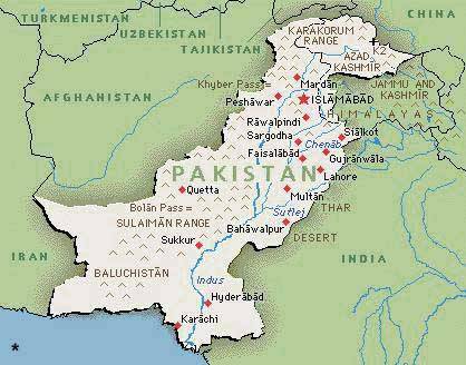
PUNJAB
The Punjab plain comprises mainly the province of Punjab. It is the gift of River Indus and its five eastern tributaries- Jhelum, Chenab, Ravi, Sutlej and Beas. The plain spreads from the south of Potohar plateau up to Mithankot, where Sulaiman Range approaches river Indus. The Punjab plain is almost a featureless plain with a gentle slope southward averaging one foot to the mile. The only break in the alluvial monotony is the little group of broken hills(100 ft-1,600ft.) near Sangla and Irana on either side of the Chenab. The entire plain is extensively irrigated by a network of canals. This system has been greatly expanded and improved in recent years by the construction of link-canals, dams and barrages as a result of the Indus Water Treaty with India, which awarded the three western rivers (Indus, Jhelum and Chenab) to Pakistan, and the three eastern rivers (Ravi,Sutlej and Beas) to India. Tarbela Dam on river Indus and Mangla Dam on River Jhelum, which have water storage capacities of 11.1 million acre ft. and 5.55 million acre ft. respectively, need a special mention. Irrigation water is supplemented by summer and winter rains(15-20 inches) so that a variety of crops is raised, the major one being wheat, rice, cotton and sugarcane. The region has earned the name of granary of Pakistan. However, the blessings of canal irrigation have not been without a curse, which render about 100,000 acres of land unproductive every year through water-logging and salinity. The menace has been greatly controlled through salinity control and reclamation projects. Agricultural development boosted urbanization and industrialization so that the region has emerged as the most important economically developed area of Pakistan, containing over 56 per cent of the population and most of the commercial and industrial centres of the country, such as Lahore (2,922,000), Faisalabad (1,092.000). Multan (730,000), Gujranwala (596,000), Sialkot (297,000) and Gujrat (154,000).
The south eastern section of the region known as Cholistan is under-developed. This tract is parched and thirsty. The summer temperature average 51.7oC and the area remains under the grip of extremely hot winds. The surface of this desert consists of a succession of sand dunes rising in places to a height of 500 ft. with vegetation peculiar to sandy tracts. There is no soil down to the lowest depth except sand; bitter water is, however, sometimes found at depth of about 80-100 ft.
The Potohar Upland, commonly called the Potohar Plateau, lies to the south of northern mountains and is flanked in the west by River Indus and in the east by River Jhelum. This 1,000-2,000 ft.(305-610 m) upland is a typical arid landscape with denuded and broken terrain characterised by undulations and irregularities. These are a few outlying spurs of Salt Range in the south, and those of Khair Murad and Kala Chitta Range in the north. Two seasonal streams-Rivers Haro and River Soan-flow from east to the west and after crossing the region in the north and in the middle respectively, fall in the Indus. River Kanshi traverses the eastern part of the plateau from north to south and drains into River Jhelum. These rivers and other hill torrents have cut deep valleys and are of little use for irrigation. Agriculture is thus almost entirely dependent on rainfall of 15-20 inches and on the small dams built in the catchment areas of the streams.
Fields of wheat, barley, jowar, bajra and pulses are found in valley bottoms and on the terraced slopes along river banks. A new economic factor has been introduced by the establishment of a few factories in Rawalpindi and Islamabad and a large industrial area in the Taxila-Wah-Hassanabdal triangle, where a large cement factory was already in existence. The region is particulary known for its oilfields in Khaur-Dhulian neighbourhood, the ancient civilization sites in Soan valley, the ruins and the Buddhist University at Taxila and the new capital, Islamabad, which stands north of the old city of Rawalpindi (806,000) at the southern slops of Murree hills, the popular Holiday resort of the country. Salt Range The ramparts of the Salt Range stretching from east to west in the south separate potohar upland from the Punjab plain. The average height of the Salt Range is about 700 metres, but near Sakesar in Sargodha district, it rises to 1,500 metres, making summer pleasant. The southern face is remarkably steep, dissected and intensely arid. But, the northern slope is gentle and has sparse vegetation of oleanders and wild olives. The top of the range is a narrow belt of isolated plateaus and basins, where, sparse stunted trees and fields of wheat and maize are found. However, the real importance of the salt mines lies in the large deposits of pure salt at Khewra and Kalabagh and the large seams of coal at Dandot and Makerwal.
SINDH
The Sindh plain comprises mainly the province of Sindh and stretches between the Punjab plain and the Arabian Sea. River Indus flows here as a single river and the plain comprises a vast fertile tract stretching westward from the narrow strip of flood plain on the right bank of River Indus, and a vast expanse of desert stretching eastward from the left bank. The desert area is dry and desolate like Cholistan in the Punjab plain. But, the plain area right of River Indus is green with a vast stretches of vegetation lined everywhere with avenues of trees.
It is the heart of the Indus Valley Civilization dating back to 3rd millennium B.C. Thousands of tourists from all over the world are attracted every year to visit the ruins of Moenjodaro near Larkana. An elaborate canal system taken from Sukkur Barrage at Sukkur, Upper Sindh Barrage north of Sukkur at Guddu, and Lower Sindh Barrage (Ghulam Muhammad Barrage) at Hyderabad, irrigate together in this area over 10,000,0000 acres and account for about 40 per cent of Pakistan's irrigated land. The fertile area yields abundant crops of rice, wheat and cotton and contains the bulk of the population and most of the major commercial and industrial centres of Sindh such as Hyderabad(795,000), Sukkur (193,000), Larkana (123,000), Nawabshah (102,000), Shikarpur (88,000) and Dadu (39,000).
However, its southern part is one of the worst areas of Pakistan for waterlogging and salinity. There are many lakes in Sindh,which attract thousands of migratory birds during the winter season from Central Asia. Manchhar lake with its highly pulsating expanse of about 200 sq. miles of area is the largest lake. With its foliage of towering grasses, its meadows of floating lotus, its inhabitants in their floating habitations, the lake presents an attractive look. Further south, stretches the Indus Delta, which is a savage waste. An important feature is the Kinjhar Lake near Thatta, which acts as a great reservoir for feeding canals in the adjacent areas. During winter, it is an ideal spot for fishing and duck shooting. South of the Kinjhar Lake, the surface is broken and littered with abandoned channels of distributries, sandy beaches, ridges and mangrove swamps, all merging into the dead creeks, grate and salt water of the coast of Rann of Kutch. At the extreme north-western end of the delta stands Karachi, the largest city and the industrial and commercial hub of Pakistan. It is also the port for Pakistan and terminal of Pakistan's railway system and the site of the country's principal international airport. Climate and Seasons As Pakistan is located on a great landmass north of Tropic of Cancer, between latitudes 24 and 37 N, it has a continental type of climate, characterized by extreme variations of temperature.
The areas closer to the snow-covered northern mountains are cold. Temperatures on the Balochistan Plateau are comparatively high. Along the coastal strop, the climate is modified by sea breezes. In the rest of the country, temperature rises steeply in the summer and hot winds, called "loo", blow across the plains during the day, dust storms and thunder storms occasionally lower the temperature. The diurnal variation in temperature may be as much as 11 to 17oC. Winters are cold with minimum temperature of about 4oC in January. Rainfall Pakistan experiences a general deficiency of rainfall.
NWFP
Khyber Pass, the largest and the most renowned of these, is 56 kilometres long and connects Kabul in Afghanistan with the fertile vale of Peshawar in the NWFP. The Tochi Pass connects Ghazni is Afghanistan with Bannu in Pakistan and the Gomal Pass provides a route from Afghanistan to Dera Ismail Khan which overlooks the Punjab Plain. the Bolan Pass connects the Sindh Plain with Quetta in Balochistan and onward through Chaman with Afghanistan. Enclosed by the branches of western mountains are a number of fertile plains which have been formed by rivers rising from these mountains and falling into Indus. From north to south are the vale of Peshawar (Kabul River), Kohat Plain (Kohat River) and Bannu Plain (River Kurram and Tochi), Peshawar valley covers some 2,200 sq. miles (5,698 sq.km) and is very fertile. It is irrigated by a network of canals which are supplemented by water of the Warsak Dam on Kabul River. Wheat, maize, sugarcane tobacco and sugar-beet are cultivated in large quantities. Large industrial Plants have been established at Peshawar, Mardan, Nowshera and Charsadda. The sugar mills at Mardan and Charsadda are reported to be the largest in Asia. Kohat valley is uneven and broken, but has fertile soil. The Tanda Dam on River Kohat supplemented water of the tube-wells and the small tanks formed by damming the rivers. Wheat, barley, gram, maize, rice and melons are grown in substantial quantities. Kohat (76,000), an important town, owes its significance as a marketing centre and a cantonment. The Bannu lowland is made of sandy and gravelly materials brought down by rivers, except for a small area near Bannu town (43,000), which contains rich silt. Perenial irrigation, made possible by the construction of the Kurram Garhi Dam on River Tochi, is confined to the land between River Kurram and River Tochi. The Bannu plain produces wheat, gram, maize, barely, rice and sugarcane. In non-irrigated parts of Kohat and Bannu plains are raised flat tailed sheep, camels and donkeys and wool is the most important commercial crop.
BALOCHISTAN
Balochistan Plateau East of the Sulaiman and Kirthar ranges lies the Balochistan Plateau with an average altitude of 2,000 ft.(610 m). The physical features of the plateau are very varied, but mountains, plateaus and basins predominate the scene. The Mountains spread in various directions, attaining height 6,000- 11,000 ft. (1,830-3,335 m).
In the north are the Toba Kakar Range and Chagai hills which form the border of Pakistan with Afghanistan for some distance. In the west-central part is the Siahan Range and in the east-southern corner the Mekran Range. Except for the Toba Kakar Range, which is dotted here and there with juniper, tamarisk and pistachio trees, all other ranges are naked and bleak. The mountains are carved off by innumerable channels and hill torrents which contain water only after rains. Very little water, however, reaches the basins lying on their foot. Comparatively more important rivers are Zhob, Bolan and Mulla, located in the north-eastern portion of Balochistan.
The valleys of the main streams and their tributaries exhibit similar feature and consist of flat plains of alluvial soil in the centre, with a pebbly slope of varying length rising on either sides of the mountains. It is from these pebbly beds that the supply of water for irrigation is chiefly obtained through Karezes. Zhob, Bloan and their tributaries have formed two important alluvial basins of Balochistan, namely, the Lorlai basin and Quetta basin, which together produce a major portion of Balochistan's crops and fruits: wheat, barley, maize, lucerne, potato, apple, apricot, peach, almond, grape and pomegranate. Kalat Plateau at 7,000-8,000 ft. (2,135-2,440 m), in the centre of Balochistan is the most important plateau.
The largest desert is found in western Balochistan. This is an area of inland drainage and dry lakes (hamuns), the largest of which is Hamun-i-Mashkhel, which is 54 miles long and 22 miles wide. The surface is littered with sun-cracked clay, oxidized pebbles, salty marshes and crescent-shaped moving sand dunes. The area is known particularly for its constant mirage and sudden severe sand-storms. Being outside the sphere of monsoon current, Balochistan receives scanty and irregular rainfall (4 inches); the temperature is very high in summer and very low in winter.
Owing to continuous draught, there is very little vegetation. Most of the people, therefore, lead nomadic life, raising camels, sheep and goats. Balochistan is, however, fortunate to have considerable mineral wealth of natural gas, coal, chromate, lead, sulphur and marble. The reserves of natural gas at Sui are among the largest in the world. The gas is piped to Karachi, Hyderabad, Sukkur, Multan, Faisalabad, Lahore, Rawalpindi and Quetta for use as industrial power.
|
 PAKISTAN IS FIRST MUSLIM NUCLEAR POWER